Barcelona El Prat Airport (BCN)
City Orientation and Maps
(Barcelona, Spain)
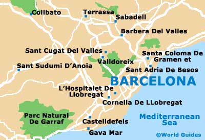
Barcelona is a bustling city, located on the eastern side Spain, next to the Mediterranean Sea and near to southern France. The coastline edges Barcelona and runs in a north-easterly / south-westerly direction, with many streets running alongside. Barcelona Airport (BCN) is situated around 10 minutes away and is easy to reach by road.
The main thoroughfare in the city of Barcelona is La Rambla, which stretches for more than 1.25 km / 0.8 miles between the Placa de Catalunya and Port Vell. Lined with mature trees, La Rambla has become synonymous with Barcelona over the years and is now a famous landmark in its own right, being full of shops, cafes, Tapas bars and bags of character.
Barcelona Airport (BCN) Maps: Important City Districts
A maze of narrow streets and alleys can be found in the Ciutat Vella area of Barcelona, where many historic buildings and local restaurants also reside, standing on each side of La Rambla. The lowest, eastern area is known locally as the Gothic Quarter, while to the west, El Raval is a lively spot, full of culture and entertainment. To the north-east, Barcelona's Parc de la Ciutadella provides an important recreational space and features many colourful flower borders.
Barcelona's Old Port (Port Vell) contains two large marinas and a host of waterfront attractions, such as the aquarium, which is suitable for all ages. On the north-eastern side of Port Vell you will find a selection of beaches, a seafront promenade and the Port Olimpic area, brimming with eateries and al fresco dining opportunities.
Spain Map

Barcelona Map